The war shaking the Middle East today is not limited to strikes, missiles and drones. It also infiltrates a dimension that is quieter but just as strategic: the satellite signals that guide aircraft and ships around the world.
Since the start of the conflict between the United States, Israel and Iran, the region has seen a troubling rise in GPS interference, electronic jamming and spoofing — a technique that involves sending fake satellite signals to mislead navigation systems.
In a space already saturated with military tensions and vital energy traffic, these disturbances create an unprecedented situation: the sea and the sky suddenly become less legible.
An electronic war that muddles navigation
GPS has become one of the world’s most essential invisible infrastructures. Merchant ships, tankers, airliners, logistics platforms and civilian applications rely on the precision of these signals.
Yet, in the Gulf and around the Strait of Hormuz, these signals are now regularly disrupted.
Two phenomena dominate :
1- Jamming prevents receivers from capturing the satellite signal.
2- Spoofing, more sophisticated, sends a fake signal capable of convincing the ship or aircraft that it is somewhere else.
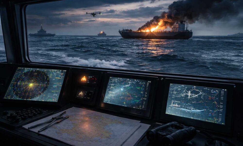
In a zone as strategic as the Strait of Hormuz — through which a substantial portion of the world’s oil transits — this loss of precision turns navigation into a much riskier undertaking.
The Strait of Hormuz, a new epicenter of maritime incidents
Since the military escalation, maritime incidents have multiplied in the region.
Several ships have been damaged by unidentified projectiles, others have reported explosions or on-board fires, while some captains have reported navigation anomalies linked to electronic interference.
Among the most notable events:
-
a tanker struck off the coast of Ras Al Khaimah, causing a fire that was brought under control
-
a vessel struck in Bahrain’s port by two unidentified projectiles
-
a tanker damaged near Fujairah
-
another vessel reporting a probable hull breach after a suspected explosion in Iraq
Individually, each of these incidents could stem from an attack, debris from military equipment, or an accident. But their rapid multiplication in a confined space reveals a clear deterioration of maritime security.
When navigation becomes uncertain
The peculiarity of the current situation is this: danger no longer comes solely from visible weapons. It also slips into the systems that normally guide ships with almost perfect precision.
GPS interferences have turned navigation into an exercise in uncertainty. The instruments, once reliable, can now sow doubt. The positions displayed on screens no longer always match reality, AIS identification systems become unstable, and the routes calculated by onboard computers may be slightly offset.
Under these conditions, sailors proceed with heightened caution, aware that amid military tensions, technology itself can sometimes muddle the bearings.
In other words, sailors must now navigate a sea where the instruments themselves can lie.
In a narrow strait where more than a hundred ships typically pass each day, a position error or a miscalculation of distance can be enough to cause a collision, grounding or a serious incident.
Severely disrupted maritime traffic
The most visible consequence of this insecurity is the dramatic drop in maritime traffic.
Many tankers and merchant ships have chosen to slow down, wait at anchor, or alter their routes, leading to a temporary collapse in the number of transits through the Strait of Hormuz.
This partial paralysis is not only a military issue: it also has major economic implications. The Strait of Hormuz is indeed one of the world’s most strategic energy corridors.
In the sky as well, navigation becomes more complicated
GPS disruptions do not affect only ships.
In civil aviation, European air safety authorities have recommended avoiding a large portion of the regional airspace.
Since the beginning of the conflict, airlines have been navigating in an increasingly unpredictable sky. Flight plans change at the last moment, routes are redrawn, and crews sometimes have to abandon their journey. Some aircraft are forced to divert to other airports, others turn back to return to their departure point, and many flights are simply canceled, leaving thousands of passengers on the ground and showing how war can, even from a distance, upend the fragile balance of global air transport.
The combination of missiles, drones and GPS jamming creates an environment where safety margins are reduced.
For now, no series of civilian crashes has been directly attributed to satellite jamming. But experts agree on one point: systemic risk is increasing.
A war that extends to invisible infrastructures
This conflict recalls a reality often forgotten: modern wars no longer unfold solely on land, at sea or in the air.
They also unfold in the invisible networks that structure our world: satellites, communications, navigation systems and digital infrastructures.
When these systems become uncertain, the consequences go far beyond the military field.
Supply chains slow down, trade routes shift, and energy markets become more volatile.
A sea more dangerous, even without battle
The Persian Gulf has not become dangerous solely because of missiles.
It is also because the reference points on which global navigation rests are starting to wobble.
In this war, a projectile can destroy a ship. But a deceptive GPS signal can, too, trigger a catastrophe.
And in a space as strategic as the Strait of Hormuz, the slightest navigation error can quickly become a geopolitical event.